|
|
|
|
||
|
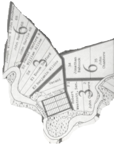
The recorded history of the small rural community of Upper Burlington is quite brief, both in detail and span of time. In fact the designation Upper Burlington came just at the end of the nineteenth century. At that time the Burlington area was split into Upper, Centre, and Lower sections to correspond with the provision of mail services which established post offices in individual communities. According to the Presbyterian Witness newspaper of April 13, 1867, the designation, Burlington, to the area just north of the Kennetcook River in Newport Township was assigned after the residents of the area met on March 30, 1867 and voted to change the name from Lower Kennetcook. The general history of the community is bound with that of Nova Scotia itself. A version of the community history was compiled by Ruth Shaw’s students in the winter of 1941, as part of a project for all Hants County rural schools initiated at Teachers’ Institute that school year by Inspector Murray Campbell. This compilation was published by the West Hants Historical Society in 2008. The map of Upper Burlington on page 68 is derived from that publication. The early “European history” of Nova Scotia was one of English-French conflict that lasted over 150 years from the founding of Port Royal in 1604 to the fall of Louisbourg in 1758. In that interval there were many episodes of military conflict connected to the larger rivalry in Europe and the eastern section of North America. The culmination came with the Seven Years War of 1756-1763 that settled the claim in favor of England. Just prior to that Halifax was founded by England in 1749, and Fort Edward was built on the Avon River the next year adjacent the settlement Piziquid that was renamed Windsor as part of the final attempt to establish English authority. Aboriginals frequented the area near the Kennetcook River prior to European colonization. Local farmers unearthed skulls and skeletons as recently as 1935. The Isaac Deschamps Papers in the Nova Scotia Archives relates a Miq’Maq group of 38, lead by a Joseph Nocout, living on the Kennetcott (sic) River in 1763-64. The West Hants Historical Society gives a mention of the early Acadian settlement in the vicinity in the booklet “A Brief History of Centre Burlington”. Prior to the Expulsion in 1755 Acadian houses were located in Upper Burlington near the northwest end of the Great Dyke according to that publication. The area had the name “Des Aigles” (“Some Eagles”), no doubt due to quite a few of those fish eaters inhabiting the area, a population that has returned recently after being absent many years. The French spelling of the river’s name is rendered as Quennetcou according to Duncanson in his book on the founding of the Newport Township. The expelled Acadians were succeeded in 1760-62 by the Planters from Rhode Island under the sponsorship of the British government of the colony of Nova Scotia. The influx to Burlington and surrounding areas is extensively documented in John Duncanson’s book “Newport:A Rhode Island Township”, with maps that show all the original 500 acre land grants in Newport township including the lots in what became Upper Burlington.
There is only one structure in Newport Township known to predate the Expulsion and subsequent Planter settlement. That is the Stone House in Poplar Grove recently and lavishly restored by Sherman Hines. That building was constructed as a French mission in the late 1600s. It has a connection to the Upper Burlington school as it was the parental home of the Upper Burlington teacher in the year 1900, Miss Janet May Allison. The original Planter grantee was a George Brightman of which a bit more later. In the 1759 subdivision of the area of Newport for the Planter lots a large section of land was designated public in Upper Burlington adjacent to the small dyke lots. Although that land was later moved to private ownership, the school was subsequently built near the originally designated public lot. Frequent changes in the resident families have followed since 1760. Among those 500 acre grants of that time it appears that a portion of one only has been occupied by the same family line, that being the original John Chambers grant which was immediately traded for the Brightman grant in Poplar Grove. The Brightman property in Upper Burlington succeeded on the male side for almost 200 years, but then on the female side through Ettinger and Lynch names since. Thus we have two odd links between Upper Burlington and the lot containing the Stone House several miles distant. While the network of roads and bridges that were built over the past 250 years in Upper Burlington has changed substantially, one can locate existing homes and roads within the boundaries of those initial lots, revealing the pattern of subdividing and road construction that has occurred. The present concrete span over the Kennetcook River is at least the fourth in that vicinity. A drawing was made in 1817 by Lt. James Woolford, aide to Governor George Ramsey, Earl of Dalhousie, of the first bridge built there in 1796. That bridge was built to replace a ferry. The present two-lane reinforced concrete bridge was preceded just upriver by a wooden bridge built in 1840. This bridge had a cover added about 1865. In 1896 a tender was published for timbers and rocks needed for building a single lane multi-span iron bridge. The latter was the first built under provincial control, responsibility for bridges passing from municipal to provincial government in 1895. It was built slightly downriver from the present bridge. The old approach roads to both of these former bridges are visible from the south side of the river. At low tide the stone remnants of both former bridges are sometimes visible. A significant event in Upper Burlington history was the forest fire of 1850, which burned 1000 acres in the community, destroying all but the Sanford home on Highway 215. Although still standing in the 1950s this home was subsequently replaced.
Among the few historical structures evident in Upper Burlington are some remnants of the old Acadian dykes in the marsh area south of the Brightman/Ettinger/Lynch property. Vestiges of some former main roads are visible on that same property just north of the Riverview Cemetery, and also in a section just north of the school, abandoned in the 1950s, of the Old Walton Road. The area developed slowly after the Planter settlement, based on subsistence farming and lumbering, boosted for a period in the mid-1800s by the spurt of wooden shipbuilding and ship owning that gave a brief prosperity to the shore region from Windsor around to Maitland, continuing into the 1880s. Open pit gypsum mining in nearby Wentworth Road and Mantua has been carried on for over 200 years providing employment to some community residents at various times. That mining is signaled today by regular sirens preceding a daily blast as more ore is loosened. Those afternoon blasts used to rattle the school’s floor and windows, perhaps startling any late afternoon scholars. The Midland Railway built in 1899 was also a major local development, providing another transportation link for people and goods. Students in Upper Burlington’s school no doubt heard its whistle many days. As in most of Nova Scotia major outmigrations occurred during too frequent economic downtimes, particularly in the 1885-1960 period, with many relocating to the USA from Massachusetts to California, or to other regions of Canada, as the Nova Scotia economy declined relative to that in those other areas. The ten children of Isaac and LeMira Harvie who lived in Upper Burlington at 303 North River Road, from 1866-1916 are examples of that. The children, born between 1865 and 1889, would have been among the early beneficiaries of the Free Schools Act of 1864-66, and been educated in the local school. Another Upper Burlington beneficiary would have been Mary Athalia Smith, born in 1860 to parents Elisha James Smith and Hannah Jane (Baker) Smith at what is now 60 Barkhouse Road. The descendants of former residents have returned from time to time to inquire about where parents, grandparents, and even earlier generations lived and went to school, and to visit cemeteries where ancestors are buried. The cemeteries in the area and the school may be the only two locations with lengthy connection to ancestors or evidence of the past, most of the old homes, barns, and other structures having disappeared. The Arthur and Margaret Smith property is noted as a second in the community to have remained in the same family for at least 100 years, having achieved the “Century Farm” status in 2007. Those of the Dill families are the only others to surpass the 100 mark, several Dill sons from three generations back being in the school picture of 1908. Electricity began to be available in local homes following WWII as rural electrification proceeded across the province. For the first time students in Upper Burlington could study under a different light than the kerosene lamps most homes had used since the 1860s. Radios followed electricity although some homes had had battery radios a decade or so earlier. Telephones did not become common in Upper Burlington until the 1960s. Only a couple of homes had them before that. Television also followed in the 1960s, as did indoor plumbing. The nature of the rural homes that students in the one-room school attended was quite different than today. |